Trail Walking La Haye-de-Routot - La Haye de Routot - Photo

La Haye de Routot

© OpenStreetMap contributors
Length
Length
8.5 km
Max alt
Max alt
137 m
Uphill gradient
Uphill gradient
117 m
Km-Effort
Km-Effort  
10.1 km
Min alt
Min alt
72 m
Downhill gradient
Downhill gradient
117 m
Boucle
Boucle
Yes
Creation date :
2019-04-25 12:06:32.394
Updated on :
2019-04-25 14:46:38.266

(0 Reviews)

Walking
Walking
2h39
Difficulty : Very easy

Scan this QR Code to open this trail in the SityTrail application

FREE GPS app for hiking

Logo SityTrail SityTrail

IGN / Geographical institutes

Download SityTrail from the App Store Download SityTrail from Google Play

Logo SityTrail SityTrail World

The world is yours!

Download SityTrail from the App Store Download SityTrail from Google Play Download SityTrail on Huawei AppGallery

About

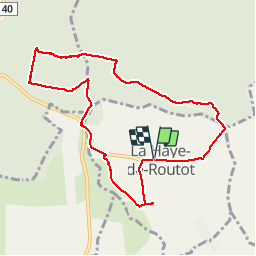
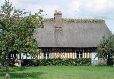
Trail Walking of 8.5 km to be discovered at Normandy, Eure, La Haye-de-Routot. This trail is proposed by MichelRando7656.

Description

Parcours essentiellement composé de chemins forestiers. Ne pas oublier d'admirer les 2 ifs avec des chapelles et le four à  pain. Visiter aussi le musée  du sabot.

Elevation profile

Photos

Positioning

Country:
France
Region :
Normandy
Department/Province :
Eure
Municipality :
La Haye-de-Routot
Location:
Unknown
Start:(UTM)
335032 ; 5474935 (31U) N.

Trails nearby

Trail Walking La Haye-de-Routot - La Haye de Routot (32) - Photo
Walking
randovivi

Walking

Easy
(1)
La Haye-de-Routot, Normandy, Eure, France
11 km | 13.7 km-effort
2h 57min
Yes
Trail Mountain bike Vatteville-la-Rue - Foret Brotonne 2-40 - Photo
Mountain bike
tracegps

Mountain bike

Medium
(1)
Vatteville-la-Rue, Normandy, Seine-Maritime, France
40 km | 46 km-effort
4h 0min
No
Trail Walking La Haye-Aubrée - La Haye Aubrée - Le chemin aux Anes- Version 03-04 - Photo
Walking
MichelRando7656

Walking

Difficult
La Haye-Aubrée, Normandy, Eure, France
12.7 km | 14.8 km-effort
3h 19min
Yes
Trail Walking Routot - Routot , Croix - Sainte-Marie , La Haie de Routot  - Photo
Walking
MichelRando7656

Walking

Difficult
Routot, Normandy, Eure, France
13.7 km | 15.6 km-effort
4h 5min
Yes
Trail Equestrian Vatteville-la-Rue - rando viking - Photo
Equestrian
carriedanny

Equestrian

Medium
(1)
Vatteville-la-Rue, Normandy, Seine-Maritime, France
24 km | 30 km-effort
Unknown
Yes
Trail Equestrian Routot - Circuit de Routot  - Photo
Equestrian
tracegps

Equestrian

Medium
Routot, Normandy, Eure, France
12.5 km | 14.4 km-effort
2h 0min
Yes
Trail Walking Routot - Circuit de Routot  - Photo
Walking
tracegps

Walking

Difficult
Routot, Normandy, Eure, France
12.5 km | 14.4 km-effort
3h 10min
Yes
Trail Mountain bike Arelaune-en-Seine - Forêt de Brotonne - Vatteville la Rue - Photo
Mountain bike
tracegps

Mountain bike

Difficult
Arelaune-en-Seine, Normandy, Seine-Maritime, France
41 km | 51 km-effort
2h 30min
No
Trail Walking La Haye-de-Routot - La Haye-de-Routot - PT  - Photo
Walking
philippe76

Walking

Medium
(1)
La Haye-de-Routot, Normandy, Eure, France
6.8 km | 8.3 km-effort
1h 53min
Yes


Close
My subscriptions